Where is the latitude and longitude on the map. How to determine the coordinates of your home without a GPS navigator
When getting into an emergency, a person must first of all be able to navigate the terrain. Sometimes it is necessary to determine the geographical coordinates of your location, for example, to transfer to the rescue service or for other purposes. There are several handy ways to do this. But first, some theory:
The equator divides the globe into northern and southern hemispheres. There are also parallels and meridians. Parallels are circles parallel to the equator. Meridians are circles perpendicular to the equator. The prime meridian passes through the Greenwich Observatory in London. The system of parallels and meridians is a coordinate grid that is used to determine the location and target designation.
Geographic coordinates are made up of latitude and longitude, which are angular quantities that can be used to determine the position of a point anywhere on the globe.
Geographic longitude - the angle measured from the prime meridian, from 0° to 180°. If the account is kept west of Greenwich, then this will be the western longitude, if east, then the eastern. Longitude indicates how far a point is to the west or east of the prime meridian.
Geographic latitude, shows how much the point is north or south of the equator, and makes an angle from 0 ° to 90 °, counted from the plane of the equator to one of the poles - north or south. It follows that the latitude is also north and south.

Schematic definition of latitude and longitude
Geographic coordinates are measured in degrees, minutes and seconds. A degree of geographic latitude is 1/180 of a meridian. The average length of one degree of latitude corresponds to approximately 111.12 km. The average length of one minute corresponds to 1852 m (10 cables, or 1 nautical mile). The diameter of the Earth (the length of the earth's axis) between the poles is 12713 km.
Determination of geographic longitude
A degree of longitude is 1/360 of the equator. Since the globe makes a full rotation on its axis in 24 hours, then in 1 hour of time the Earth passes 15 ° of longitude. Respectively:
1° longitude = 4 min. time
1´ = 4 sec time
1" = 1/15 sec time
Based on the above, there is a way to determine the geographic longitude of your location using a watch. To do this, you must have a clock whose time is set at a place with a known longitude and note their readings at local noon, and convert the difference of this time into a degree measure:

Definition of local noon
one). Recalculate your watch to GMT, taking into account the zone corrections (the place in which they are set, if not GMT), daylight savings time and daylight savings.
2). Find noon in the area. To do this, you need to use the gnomon - the oldest sundial, i.e. stuck strictly vertically into the ground with a stick 1-1.5 m. And mark the length of the falling line by marking on the ground. As the sun approaches the zenith, the shadow will begin to shorten, and at the moment when it becomes the shortest, this will be the true solar time at noon in this area, i.e. your sundial shows 12 hours. I would like to note that at noon the shadow of the stick will be directed strictly from south to north.
3). Record your watch - this will be Greenwich Mean Time. Further, the correction from the table should be subtracted from this time, taking into account the sign, since the angular velocity of movement is not constant and depends on the time of year, thereby bringing the mean Greenwich time to true solar.
And now calculate the difference between the true solar time at noon, i.e. 12h and the resulting GMT time, taking into account the correction. The result obtained is converted into a degree measure, this will be the geographic longitude of the area.
Example: the date is May 2, your watch is set to Moscow time. Moscow summer time differs from world summer time by 4 hours. At local noon, the clock showed 18 hours 36 minutes. Hence the Greenwich Mean Time at that moment was 14 hours 36 minutes. We make an amendment + 3 min on May 2. Subtract 12 hours from this, we get 2 hours 36 minutes. taking into account the amendment for May 2, we add 3 minutes and translate into an angular measure. And we get 39 ° west longitude, because local noon came later than GMT.
14:36 + 3min = 14:39 - true solar time
14:39 - 12h = 2:39 = 39° west longitude

Table 1 - Add the correction (with its own sign) to the clock readings to obtain true solar time
The second way is to bring the true solar time at noon to the average, adding to it the correction from table 2, i.e. add the correction to 12h, taking into account the sign 
Table 2 - Bringing the true solar time to the average
Example: The date is October 7th. You have determined solar noon, i.e. 12h. Your clock is set to GMT and shows 8:20. True solar time must be converted to the mean, since the GMT clock also shows the mean. This means that the correction for October 7 is -12 min. (table 2)
12h - 12min = 11:48 am - local mean time 11:48 - 8:20 am = 3:28 am = 55° east longitude because local noon is earlier than Greenwich Mean Time
In fact, tables 1 and 2 differ only in signs. For example, on May 14, from table 1, the correction will be + 3 min, and from the second - 3 min. Therefore, you can use, for example, Table 1 and bring the average time to true solar, and if you bring true solar to the average, then take the opposite sign of the correction. In my opinion, it is more convenient to use the first method, then you will always correct for Greenwich Mean Time and calculate the difference from 12h (true noon)
Or even easier - first calculate the difference between the true solar and mean Greenwich time, and correct the result taking into account the sign from table 2.
Remember, if at the time of local noon GMT is less than 12 hours, then you have east longitude, if more than 12 noon, then west. This method allows you to determine longitude with an accuracy of 2-3 °, and being in extreme situations, you most likely will not have a time equation table at hand to correct for the season, so only due to this the result will differ from the true one by 0 ° - 4°, depending on the season.
Definition of geographic latitude
Latitude can be determined in several ways.
Method number 1. With the help of a protractor and a plumb line. A protractor can be made from two rectangular strips fastened in a compass so that you can change the angle between them.
one). In the center of the protractor, fasten the thread with a load that plays the role of a plumb line.
2). Point the base of the protractor at the polar star.
3). Subtract 90° from the angle between the base of the protractor and the plumb line. The result will be the angle between the pole star and the horizon. Since the polar star has an angular deviation from the axis of the pole of the world by only 1 °, the angle between the polar star and the horizon will be the latitude of the area in which you are located.

Method number 2.
one). Record the length of the day between sunrise on the horizon and full sunset.
2). In the nomogram for determining the latitude, put the received length of the day on the left side, and the date on the right side. Connecting the obtained values with a straight line, determine where it intersects with the middle part. This intersection will be the latitude of your area.

Nomogram for determining geographic latitude
The ability to determine where the latitude or longitude is on the map is important for a person. Especially when there was an accident and you need to quickly make a decision and transfer the coordinates to the police. She is recognized in a variety of ways. They mean the angle that is a vertical line and 0 parallel at a predetermined point. The value is only up to 90 degrees.
Do not forget that the equator divides the earth into northern and southern hemispheres. Therefore, the latitude of earthly points that are higher than the longest parallel are northern, and if they are located below, then southern.
How to find out the latitude of any object?
You can determine the latitude and longitude on the map. Look at which parallel the object is marked. If it is not specified, then independently calculate the distance between neighboring lines. Then find the degree of parallel you are looking for.

At the equator, geographic latitude is 0°. Points that are on the same parallel will have the same latitude. If you take a map, you will see it on the frames, if a globe, then where the parallels intersect with 0° and 180° meridians. Geographic latitudes range from 0° and only up to 90° (near the poles).
5 major latitudes
Take a map, there you will see the main parallels. Thanks to them, the coordinates are easier to recognize. From the latitudinal line to the line, territories are located. They belong to one of the areas: temperate or equatorial, arctic or tropics.
The equator is the longest parallel. Lines that are lower or higher decrease towards the poles. The latitude of the equator is 0°. This is the point from which the parallels are counted towards the south or north. The area that starts from the equator and stretches to the tropics is the equatorial region. Tropic north - the main parallel. It is always marked on the maps of the world.

You can find the exact coordinates of 23° 26 min. and 16 sec. north of the equator. This parallel is also called the Tropic of Cancer. Tropic South is a parallel located at 23° 26 min. and 16 sec. south of the equator. It is called the Tropic of Capricorn. The area that is located in the middle of the line and to the equator are tropical regions.
At 66° 33 min. and 44 sec. Just above the equator is the Arctic Circle. This is the border, beyond it the duration of the night increases. Near the pole it is 40 calendar days.
Latitude of the Antarctic Circle -66° 33 min. and 44 sec. And this is the border, and beyond it there are polar days and nights. The regions between the tropics and the described lines are temperate, and those beyond them are called polar.
Instruction
Step #1
Everyone knows that the equator divided the earth into southern and northern hemispheres. In addition to the equator, there are parallels. These are circles that are parallel to the equator itself. Meridians are conditional lines that are perpendicular to the equator.

The zero meridian passes through the observatory, it is called the Greenwich observatory and it is located in London. That's why they say so: "Greenwich Meridian". The system, which includes parallels with meridians, creates a grid of coordinates. It is used when they want to determine where an object is located.
Step #2
Does the geographic latitude show this point to the south or north of the equator? It defines the angle 0° and to 90°. The angle begins to count from the equator and to the south or north pole. So you can determine the coordinates, they say that the latitude is southern or northern.
Step #3
Geographic coordinates are measured in minutes with seconds, and most importantly - in degrees. A degree of a certain latitude is 1/180 of any of the meridians. The average length of 1 degree is 111.12 km. A minute in length is 1852 m. The diameter of Mother Earth is 12713 km. This is the distance from pole to pole.

Step #4
To find out latitude 1 in the described way, you need a plumb line with a protractor. You can make a protractor yourself. Take a few rectangular planks. Fasten them like compasses so that they change the angle between them.
Step #5
Take the thread. Hang a load (plumb) on it. Anchor the thread in the center of your protractor. Point the base of the protractor at the polar star. Do some geometric calculations. Specifically, from the angle that is between the plumb line and the base of your protractor, immediately subtract 90 °. This result is the angle that passes between the polar star and the horizon. This angle is the geographic latitude where you are.
Another way
There is another option, how you can find the coordinates. It doesn't look like the first one. Wake up before sunrise and spot its beginning, and then the sunset. Pick up a monogram to find the latitude. On the left of the monogram, set aside how long the daylight hours lasted, and write the date on the right.

Even in the middle of the XVIII century. such coordinates could be learned on the basis of astronomical observations. In the 20s. The 20th century can already be contacted by radio and determine the coordinates with special tools.
We suggest using a similar service from Google - + location of interesting places in the world on the Google Maps scheme
Calculation of the distance between two points by coordinates:
Online calculator - calculation of the distance between two cities, points. Their exact location in the world can be found at the link above.
Countries in alphabetical order:
Finding latitude and longitude on a map?
On the page, a quick determination of coordinates on the map - we find out the latitude and longitude of the city. Online search for streets and houses by address, using GPS, to determine the coordinates on the Yandex map, how to find the location is described in more detail below.
Determining the geographical coordinates of any city in the world (find out the latitude and longitude) using the online map from the Yandex service is actually a very simple process. You have two convenient options, let's take a closer look at each of them.
Fill out the form: Rostov-on-Don Pushkinskaya 10 (with the help of and if you have a house number, the search will be more accurate). On the right in the upper corner there is a form for determining the coordinates, which contains 3 exact parameters - the coordinates of the mark, the center of the map and the zoom scale.
After activating the "Find" search, each field will contain the necessary data - longitude and latitude. We look at the "Center of the map" field.
Second option: In this case, even easier. An interactive world map with coordinates contains a marker. By default, it stands in the center of the city of Moscow. It is necessary to drag the label and put it on the desired city, for example, we determine the coordinates on . The latitude and longitude will automatically match the search object. We look at the field "Label coordinates".
When searching for the city or country you need, use the navigation and zoom tools. By zooming in and out +/- , as well as moving the interactive map itself, it is easy to find any country, search for a region on the world map. Thus, you can find the geographical center of Ukraine or Russia. In the country of Ukraine, this is the village of Dobrovelichkovka, which is located on the Dobraya River, Kirovohrad Region.
Copy geographical coordinates of the center of Ukraine Dobrovelichkovka - Ctrl+C
48.3848,31.1769 48.3848 north latitude and 31.1769 east longitude
Longitude +37° 17′ 6.97″ E (37.1769)
Latitude +48° 38′ 4.89″ N (48.3848)
At the entrance to the urban-type settlement there is a sign informing about this interesting fact. Considering its territory is likely to be uninteresting. There are far more interesting places in the world.
How to find a place on the map by coordinates?
Consider the reverse process, for example. Why do you need to determine the latitude and longitude on the map? Suppose you need to determine the exact location of the car on the map using the coordinates of the GPS navigator. Or a close friend will call on the weekend and give you the coordinates of his location, inviting you to join the hunt or fish.
Knowing the exact geographical coordinates, you will need a map with latitude and longitude. It is enough to enter your data into the search form from the Yandex service in order to successfully determine the location by coordinates. Example, we enter the latitude and longitude of Moskovskaya street 66 in the city of Saratov - 51.5339,46.0368. The service will quickly determine and show the location of this house in the city as a marker.
In addition to the above, you can easily determine the coordinates on the map of any metro station in the city. After the name of the city, write the name of the station. And we observe where the label and its coordinates with latitude and longitude will be located. To determine the length of the route, it is necessary to use the "Ruler" tool (measurement of distances on the map). We put a mark at the beginning of the route and then at the end point. The service will automatically determine the distance in meters and show the track itself on the map.
It is possible to more accurately examine a place on the map thanks to the “Satellite” scheme (upper corner on the right). See what it looks like. You can do all of the above with it.
World map with longitude and latitude
Imagine you are in an unfamiliar area, and there are no objects or landmarks nearby. And there is no one to ask! How could you explain your exact location so that you can be found quickly?
Thanks to concepts such as latitude and longitude, you can be discovered and found. Latitude shows the location of an object in relation to the South and North Poles. The equator is considered to be zero latitude. The South Pole is located at 90 degrees. south latitude, and North at 90 degrees north latitude.
These data are not enough. It is also necessary to know the situation with respect to East and West. This is where the longitude coordinate comes in handy.
Thank you for the provided data service Yandex. Cards
Cartographic data of cities in Russia, Ukraine and the world
There are many different coordinate systems. All of them are used to determine the position of points on the earth's surface. This includes mainly geographic coordinates, flat rectangular and polar coordinates. In general, it is customary to call coordinates angular and linear quantities that define points on a surface or in space.
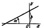
Geographic coordinates are angular values - latitude and longitude, which determine the position of a point on the globe. Geographic latitude is the angle formed by the plane of the equator and a plumb line at a given point on the earth's surface. This angle value shows how far a particular point on the globe is north or south of the equator.
If the point is located in the Northern Hemisphere, then its geographical latitude will be called northern, and if in the Southern Hemisphere - southern latitude. The latitude of points located on the equator is zero degrees, and at the poles (North and South) - 90 degrees.
Geographic longitude is also an angle, but formed by the plane of the meridian, taken as the initial (zero), and the plane of the meridian passing through the given point. For the uniformity of the definition, it was agreed to consider the meridian passing through the astronomical observatory in Greenwich (near London) as the initial meridian and call it Greenwich.
All points located to the east from it will have eastern longitude (up to the meridian of 180 degrees), and to the west of the initial one - western longitude. The figure below shows how to determine the position of point A on the earth's surface if its geographical coordinates (latitude and longitude) are known.
Note that the difference in longitudes of two points on Earth shows not only their relative position with respect to the zero meridian, but also the difference in these points at the same moment. The fact is that every 15 degrees (24th part of the circle) in longitude is equal to one hour of time. Based on this, it is possible to determine the difference in time at these two points by geographical longitude.
For example.
Moscow has a longitude of 37°37′ (East), and Khabarovsk -135°05′, that is, lies to the east of 97°28′. What time do these cities have at the same moment? Simple calculations show that if it is 13:00 in Moscow, then it is 19:30 in Khabarovsk.
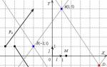
The figure below shows the design of the sheet frame of any map. As can be seen from the figure, in the corners of this map, the longitude of the meridians and the latitude of the parallels that form the frame of the sheet of this map are signed.

On all sides, the frame has scales divided into minutes. For both latitude and longitude. Moreover, each minute is divided by dots into 6 equal sections, which correspond to 10 seconds of longitude or latitude.
Thus, in order to determine the latitude of any point M on the map, it is necessary to draw a line through this point parallel to the lower or upper frame of the map, and read the corresponding degrees, minutes, seconds on the latitude scale to the right or left. In our example, point M has a latitude of 45°31’30”.
Similarly, drawing a vertical line through the point M parallel to the lateral (closest to this point) meridian of the border of this sheet of the map, we read the longitude (east) equal to 43 ° 31'18 ".
Drawing a point on a topographic map according to given geographical coordinates.
Drawing a point on the map according to the given geographical coordinates is carried out in the reverse order. First, the indicated geographical coordinates are found on the scales, and then parallel and perpendicular lines are drawn through them. Intersecting them on will show the point with the given geographic coordinates.
Based on the book "The map and the compass are my friends."
Klimenko A.I.
Geographical coordinates define the position of a point on the earth's surface or, more broadly, in a geographic envelope. Geographic coordinates are built on the principle of spherical. Similar coordinates are used on other planets, as well as on the celestial sphere.
Latitude
Main article: LatitudeLatitude- angle φ between the local direction of the zenith and the plane of the equator, counted from 0° to 90° on both sides of the equator. The geographical latitude of points lying in the northern hemisphere (northern latitude) is considered to be positive, the latitude of points in the southern hemisphere is negative. It is customary to speak of latitudes close to the poles as high, and about those close to the equator - as about low.
Due to the difference in the shape of the Earth from the ball, the geographic latitude of the points is somewhat different from their geocentric latitude, that is, from the angle between the direction to a given point from the center of the Earth and the equatorial plane.
The latitude of a place can be determined using astronomical instruments such as a sextant or gnomon (direct measurement), or you can use GPS or GLONASS systems (indirect measurement).
Longitude
Main article: LongitudeLongitude- dihedral angle λ between the plane of the meridian passing through the given point and the plane of the initial zero meridian, from which the longitude is counted. Longitude from 0° to 180° east of the prime meridian is called east, to the west - west. Eastern longitudes are considered to be positive, western - negative.
The choice of the zero meridian is arbitrary and depends only on agreement. Now the prime meridian is the Greenwich meridian passing through the observatory in Greenwich, southeast London. Previously, the meridians of the observatories of Paris, Cadiz, Pulkovo, etc. were chosen as zero.
The local solar time depends on the longitude.
Height
Main article: Height above sea levelTo fully determine the position of a point in three-dimensional space, a third coordinate is needed - height. The distance to the center of the planet is not used in geography: it is convenient only when describing very deep regions of the planet or, on the contrary, when calculating orbits in space.
Within the geographic envelope, it is usually used height above sea level, counted from the level of the "smoothed" surface - the geoid. Such a system of three coordinates turns out to be orthogonal, which simplifies a number of calculations. Altitude is also convenient because it is related to atmospheric pressure.
Distance from the earth's surface (up or down) is often used to describe a location, but "not" serves as a coordinate.
Geographic coordinate system
 Rice. one
 In navigation, the center of mass of the vehicle (TC) is chosen as the origin of the coordinate system. The transition of the origin from the inertial coordinate system to the geographic one (that is, from O i (\displaystyle O_(i)) to O g (\displaystyle O_(g))) is carried out based on the values of latitude and longitude. The coordinates of the center of the geographical coordinate system O g (\displaystyle O_(g)) in the inertial one take the following values (when calculated using a spherical model of the Earth):
X o g = (R + h) cos (φ) cos (U t + λ) (\displaystyle X_(og)=(R+h)\cos(\varphi)\cos(Ut+\lambda)) Y o g = (R + h) cos (φ) sin (U t + λ) (\displaystyle Y_(og)=(R+h)\cos(\varphi)\sin(Ut+\lambda)) Z o g = ( R + h) sin (φ) (\displaystyle Z_(og)=(R+h)\sin(\varphi)) where R is the radius of the earth, U is the angular velocity of the earth's rotation, h is the height above sea level, φ (\displaystyle \varphi ) - latitude, λ (\displaystyle \lambda ) - longitude, t - time.
The orientation of the axes in the geographic coordinate system (H.S.K.) is selected according to the scheme:
The X-axis (another designation is the E-axis) is the axis directed to the east. The Y-axis (another designation is the N-axis) is the north-facing axis. Axis Z (another designation - axis Up) - an axis directed vertically upwards.
The orientation of the XYZ trihedron, due to the rotation of the earth and the movement of the T.S., is constantly shifting with angular velocities.
ω E = − V N / R (\displaystyle \omega _(E)=-V_(N)/R) ω N = V E / R + U cos (φ) (\displaystyle \omega _(N)=V_( E)/R+U\cos(\varphi)) ω U p = V E R t g (φ) + U sin (φ) (\displaystyle \omega _(Up)=(\frac (V_(E))(R ))tg(\varphi)+U\sin(\varphi)) where R is the radius of the earth, U is the angular velocity of the earth's rotation, V N (\displaystyle V_(N)) is the speed of the vehicle to the north, V E (\displaystyle V_ (E)) - east, φ (\displaystyle \varphi ) - latitude, λ (\displaystyle \lambda ) - longitude.
The main shortcoming in the practical application of the G.S.K. in navigation is the large values of the angular velocity of this system at high latitudes, which increase up to infinity at the pole. Therefore, instead of G. S. K., a semi-free SK in azimuth is used.
Semi-free in azimuth coordinate system
The semi-free in azimuth S.K. differs from the G.S.K. only by one equation, which has the form:
ω U p = U sin (φ) (\displaystyle \omega _(Up)=U\sin(\varphi))
Accordingly, the system has the same initial position, carried out according to the formula
N = Y w cos (ε) + X w sin (ε) (\displaystyle N=Y_(w)\cos(\varepsilon)+X_(w)\sin(\varepsilon)) E = − Y w sin (ε) + X w cos (ε) (\displaystyle E=-Y_(w)\sin(\varepsilon)+X_(w)\cos(\varepsilon))
In reality, all calculations are carried out in this system, and then, to issue output information, the coordinates are transformed into the GCS.
Recording formats for geographic coordinates
Any ellipsoid (or geoid) can be used to record geographic coordinates, but WGS 84 and Krasovsky (on the territory of the Russian Federation) are most often used.
Coordinates (latitude −90° to +90°, longitude −180° to +180°) can be written:
- in ° degrees as a decimal fraction (modern version)
- in ° degrees and ′ minutes with a decimal
- in ° degrees, ′ minutes and ″ seconds with a decimal fraction (historical notation)
The decimal separator can be a period or a comma. Positive signs of coordinates are represented by (in most cases omitted) sign "+" or letters: "N" - north latitude and "E" - east longitude. Negative signs of coordinates are represented either by the sign "−" or the letters: "S" - southern latitude and "W" - western longitude. Letters can stand both in front and behind.
There are no uniform rules for recording coordinates.
By default, search engine maps show coordinates in degrees with a decimal fraction with a "−" sign for negative longitude. On Google maps and Yandex maps, latitude first, then longitude (until October 2012, the reverse order was adopted on Yandex maps: first longitude, then latitude). These coordinates are visible, for example, when laying routes from arbitrary points. The search also recognizes other formats.
At the same time, the original way of writing with degrees, minutes and seconds is often used. Currently, coordinates can be written in one of many ways or duplicated in two main ways (with degrees and with degrees, minutes and seconds). As an example, the options for recording the coordinates of the sign "Zero kilometer of the roads of the Russian Federation" - 55 ° 45′21 ″ s. sh. 37°37′04″ in. e.HGЯO:
- 55.755831°, 37.617673° - degrees
- N55.755831°, E37.617673° - degrees (+ additional letters)
- 55°45.35′N, 37°37.06′E - degrees and minutes (+ additional letters)
- 55°45′20.9916″N, 37°37′3.6228″E - degrees, minutes and seconds (+ additional letters)
GEOGRAPHIC MAP. DETERMINATION OF LATITUDE AND LONGITUDE
Globe - a model of the globe. It faithfully conveys the outlines of the continents and oceans and the ratio of their areas, which makes it possible to accurately measure the distances between individual places located on different continents, to find the shortest distances between them.
Along with the advantages, the globe has a significant drawback: it is produced only on a small scale. Imagine a globe on the scale of a wall map of Russia, then its diameter would be 2.55 m. It would be inconvenient to use such a globe, since it would take up too much space.
A degree network is applied on the globe, consisting of meridians and parallels, which can be drawn innumerable. Usually on the globe and maps they are applied through 5, 10, 15 °. The initial meridian is chosen conditionally and passes through Greenwich (a suburb of London). The equator is 40075.7 km long and divides the Earth into northern and southern hemispheres. Parallels are plotted parallel to the equator.
The degree network determines the exact position of each point on Earth, i.e. determine its geographic longitude and geographic latitude.
Geographic longitude is the angular distance of a given meridian from the initial one, while the vertex of the angle is at the center of the Earth. For ease of reference, longitude is measured east and west of the Greenwich meridian up to 180°. Longitude is called east when measured to the east (abbreviated east) and west when measured to the west (abbreviated west). Longitude is measured in degrees, minutes and seconds, for example: the longitude of St. Petersburg is 30 ° E; longitude of Vladivostok 132°E longitude New York 73°W; longitude of Moscow is 37°5" E (37 degrees 5 minutes east).
Geographic latitude is the angular distance from the equator to a given parallel. The vertex of the angle is also in the center of the Earth, but the angle does not lie in the plane of the equator, but in the plane of the meridian on which the desired point is located. Latitude is also measured in degrees, minutes and seconds from the equator to the north and south (from 0 to 90 °). The latitude is northern and southern (abbreviated as N, S), for example: the latitude of Moscow is 57 ° N, the latitude of St. Petersburg is 60 ° N, the latitude of Melbourne (Australia) is 38 ° S
The latitude and longitude of any point on the globe are its geographical coordinates.
Since the length of all meridians, in contrast to the parallels, is the same, then an arc of 1 ° of any meridian is approximately 111 km. It is somewhat less near the equator (110.57 km) and more near the poles (111.7 km) due to the compression of the Earth near the poles.
What is latitude and longitude?
All this is wonderful, only latitude and longitude are NOT lines. These are angles, that's why they are measured in degrees! - 4 years agoLongitude and latitude are concepts used in the designation of geographic coordinates.
For example, they say: the ship is at 35 degrees north latitude and 28 degrees east longitude.
How is this to be understood?
To understand, take a globe, touch your finger anywhere on the equator. Then spin the globe without removing your finger. By turning the globe, you change the position of your finger in longitude.
In the city of Greenwich there is a point where the longitude is zero degrees. This is the point through which the prime meridian passes.
Everything to the right on the map is called east longitude, and everything to the left is called west. You can also say just longitude, then the offset to the west or east will be determined by the sign of the angle. If the angle is negative, then the offset is to the west, and if positive - to the east. What is an angle? The angle is the angle between point A with X coordinates at the Greenwich level and Y coordinates at the equator level, point O located in the center of the planet and point B with X coordinates of the desired point and Y coordinates at the equator level.
Latitude is about the same, only it is plotted vertically, that is, perpendicular to longitude. What is above the equator is the north latitude, and what is below is the south. Or just latitude, then the angle decreases downward (negative angles), and upwards - increase.
Here is the diagram:

Pani monica
Latitude and longitude are geographic coordinates, conditional lines on the surface of the globe.
Latitude is a conditional horizontal line (parallel), and longitude is a vertical line. The latitude reference point starts from the equator. This is zero latitude. Latitudes from the equator to the North Pole are called North (N or N) from 0 to 90, from the Equator to the South Pole - South (S or S).

The reference point for longitude is the Greenwich meridian. This is zero longitude. The longitude going from Greenwich towards the east (towards Japan) is called Eastern longitude (E or E), from Greenwich to the west (towards America) - Western (W or W)
Each latitude and longitude is measured in degrees, each degree is divided into minutes, each minute into seconds. 1 degree = 60 minutes, 1 minute = 60 seconds. These are geometric and astronomical units of measurement.
Each degree, each minute and each second is equal to a certain distance, which changes as you approach the poles: the distance of each degree of latitude increases, and each degree of longitude decreases. All points of geographic coordinates converge at the poles, so there is only latitude (there is no longitude): the North Pole is 90 ° 00? 00? North latitude, the South Pole is 90 ° 00? 00? South latitude.


By definition, both latitude and longitude are angular coordinates that can be used to specify the location of any point on the globe. If the familiar X and Y are used on the plane, defined by metric units of measurement relative to perpendicular axes, then on a spherical surface angular coordinates are used, which show the position of a point relative to two also perpendicular lines on the surface and are measured in degrees. In the case of the Earth, these lines are the equator and the prime meridian. Latitude, north or south, is plotted from the equator, and longitude, east or west, is plotted from the prime meridian. The angle of latitude is determined by drawing conditional lines from the center of the earth to the desired point and the equator in the plane of the meridian, and the angle of longitude is determined by drawing the same lines from the center of the section of the globe by a parallel between the desired point and the zero meridian.
Tip: in order not to get confused about what latitude and longitude are, it is better to remember, for example, the concept of northern and southern latitudes - it is already becoming clear that latitude is a line above or below the equator, parallel to it, a parallel. Therefore, longitude is a line perpendicular to the equator - a meridian.
Help to
Latitude and longitude are angles. Together they form coordinates that can be used to find the position of an object on a spherical surface, like the Earth.
Latitude is determined in relation to the equator. That is, the equator is the zero surface. Positive latitude is north latitude up to +90 degrees, and negative latitude is south latitude up to -90 degrees.
Longitude is defined in terms of meridians. There is a main meridian, from which the longitude begins - this is Greenwich. All meridians to the east are negative longitude up to -180 degrees, and those to the west are positive longitudes up to + 180 degrees.
Tigre-ok
Of course, everything will depend on the meaning of the word. After all, it can be the breadth of the soul and the length of clothing. But, we take as a basis all the same geographical concepts. In order not to delve into specific and abstruse terminology, I will try to explain these concepts as simply as possible. After all, it is an accessible explanation that helps to remember information for a long time. I remember back in school we were told to imagine ourselves as travelers on a ship. And in order to understand where our ship is, we must learn to calculate latitude and longitude. To understand our location in relation to the North and South Poles, we need latitude.

Tatty
Latitude and longitude are coordinates that can be used to locate an object on the surface of our planet or some other celestial body. Longitude can be east or west. Latitude can be determined using such devices as: the gnomon is an ancient astronomical instrument and the sextant is a measuring, navigational instrument.
To determine latitude and longitude, modern satellite navigation systems such as GPS and GLONASS are used. Latitude and longitude are measured:

ingrid
It is known from school geography that geographic coordinates are used to determine the position of the Earth's points on an ellipsoid (ball). The initial planes in the system of geographical coordinates are the planes of the initial meridian and the equator, and the coordinates are angular values: longitude and latitude of the point. Determining the position of a point using latitudes and longitudes was introduced by Hipparchus in the 2nd century BC. BC e. Geographic latitude point is called corner between the equatorial plane and the normal (plumb line) drawn from the given point. Geographic longitude dots are dihedral angle between the plane of the initial (zero Greenwich) meridian and the plane of the meridian passing through the given point.
Azamatik
Good day.
Everyone, probably, at school came across, heard about such concepts as longitude and latitude.
Most often this happened in geography lessons.
So, both of these concepts denote an angle. Latitude- this is the angle between the equator, or rather its plane, and the line from this point; longitude this is the angle between the plane of the meridian passing through the given point and the plane of the zero meridian.
Longitudes from 0 to 180 ° to the east of that same zero meridian are usually called eastern (while they are usually called or considered positive), and to the west - western (they are also called negative).

Longitude is the dihedral angle between the prime (Greenwich) meridian and the local meridian. Longitudes are counted from 0 to 180, from the Greenwich meridian. In general, longitude and latitude are the data necessary to determine a point in space, in a plane, from geodetic latitude and longitude, a transition is made to flat coordinates in the Gauss-Mercator projection for compiling topographic plans for sites. Longitude and latitude are geodetic, astronomical, depending on whether what coordinate system are you considering?
Moreljuba
Latitude and longitude are purely geographical indicators that are familiar to all schoolchildren. Use latitude and longitude to compile the coordinates of the location of an object.
And now in more detail separately on each concept:
1) Here is what is meant by latitude:

2) Here is what is meant by longitude:

Longitude and latitude are used to determine a point on the earth's surface. Latitude is the distance from a certain point to the equator, and longitude is the distance to the zero point of the meridian, or Greenwich. This distance is indicated in degrees, minutes and seconds.
Adventurer 2000
Good afternoon. These values are measured in degrees, they show the coordinates of any point on the globe, if you take a globe or open a map, you will definitely find these lines on them.
Each indicator is described in detail below:

Please people! How to determine latitude and longitude on a map?
The fact is that I have a contest tomorrow, I can't let the teacher down!!! Please DETAILS who knows how to determine the latitude and longitude on the map? I don’t remember .... there is western longitude, eastern latitude ... etc. etc .... etc.
Mignonette
good luck!
san sanych
LatitudeL9; - the angle between the local direction of the zenith and the plane of the equator, measured from 0 to 90 ° on both sides of the equator. The geographical latitude of points lying in the northern hemisphere (northern latitude) is considered to be positive, the latitude of points in the southern hemisphere is negative. In addition, it is customary to talk about latitudes greater than 9; greater in absolute value - as high, and about those close to zero (that is, to the equator) - as low.
Due to the difference in the shape of the Earth (geoid) from the ball, the geographical latitude of the points differs somewhat from their geocentric latitude, i.e., from the angle between the direction to a given point from the center of the Earth and the plane of the equator.
The latitude of a place can be determined using astronomical instruments such as a sextant or gnomon (direct measurement), you can also use GPS or GLONASS systems (indirect measurement). The length of the day depends on the latitude, as well as on the time of year.
LongitudeL9; - the angle between the plane of the meridian passing through the given point, and the plane of the initial zero meridian, from which the longitude is calculated. Now on Earth, the zero meridian is the one that passes through the old observatory in Greenwich, southeast London, and therefore it is called the Greenwich meridian. Longitudes from 0 to 180 ° east of the zero meridian are called eastern, to the west - western. Eastern longitudes are considered to be positive, western - negative. It should be emphasized that, in contrast to latitude, for a system of longitudes, the choice of the reference point (zero meridian) is arbitrary and depends only on the agreement. So, in addition to Greenwich, the meridians of the observatories of Paris, Cadiz, Pulkovo (on the territory of the Russian Empire), etc. were previously chosen as zero.
The local time depends on the longitude.
Sergey 52 rus
in the google earth program, there is a GRID function, that is, a grid is drawn for the entire globe, you can check yourself and learn to understand. all parallels and meridians are signed. true in English, for example - 50 N and 50 E, that is, 50 degrees north latitude and 50 degrees east longitude. but in general, to make it easier to remember, cut the Earth in half, as it were, from north to south, and then along the equator.
Julia Ostanina
Well, it means that the object being defined has an address - this is latitude and longitude, (for example, 57 north latitude 33 east are the coordinates of the city of moscow)
latitude are horizontal lines, longitude are vertical lines.
latitude is northern and southern (northern latitude and south latitude) depends on which side of the equator the object to be determined is located.
longitude west and east (west and east) divides their prime meridian
all degrees are signed outside the frame of the map.
good luck!
Vladimir Gevorgyan
You will need a watch; - protractor.
Instruction
1First you must determine the geographic longitude. This value shows the deviation of the object from the prime meridian, from 0° to 180°. If the desired point is east of Greenwich, the value is called east longitude, if it is west, west longitude. One degree is equal to 1/360 of the equator.
Veronica Koshkina
1First you must determine the geographic longitude. This value shows the deviation of the object from the prime meridian, from 0° to 180°. If the desired point is east of Greenwich, the value is called east longitude, if it is west, west longitude. One degree is equal to 1/360 of the equator.
2Pay attention to the fact that in one hour the Earth turns 15° of longitude, and in four minutes it moves 1°. Your watch must show the correct local time. To find out geographic longitude, you need to set the local noon time.
3Find a straight stick 1-1.5 meters long. Stick it vertically into the ground. As soon as the shadow from the stick falls from south to north, and the sundial “shows” 12 hours, mark the time. This is the local noon. Convert your data to Greenwich Mean Time.
4 Subtract 12 from the result obtained. Convert this difference to a degree measure. This method does not give a 100% result, and the longitude from your calculations may differ from the true longitude of your location by 0°-4°.
5Remember, if local noon comes before noon GMT, this is east longitude, if later, west longitude. Now you must set the geographic latitude. This value shows the deviation of the object from the equator to the north (northern latitude) or to the south (south latitude) side, from 0° to 90°.
6. Please note that the average length of one degree of geographic latitude is approximately 111.12 km. To determine the geographical latitude, you need to wait for the night. Prepare the protractor and point its lower part (base) at the polar star.
7 Position the protractor upside down, but so that the zero degree is opposite the polar star. See which degree is opposite the hole in the middle of the protractor. This will be the geographic latitude.
Vladislav Pozdnyakov
latitude are horizontal lines, longitude are vertical lines.
latitude is northern and southern (northern latitude and south latitude) depends on which side of the equator the object to be determined is located.
longitude west and east (west and east) divides their prime meridian
all degrees are signed outside the frame of the map.
Hello need help! How to determine longitude and latitude?
Please give examples. Help please, just asked to determine the longitude and latitude on the contour map, I don’t understand anything Thank you in advance!
Taisiyakonovalova
1. To determine the geographic latitude, the map shows parallels - lines drawn parallel to the equator. Geographic latitude is northern and southern. All points located in the northern hemisphere have a north latitude (N), and in the southern hemisphere - a south latitude (S).
Geographic latitude shows the distance from the equator to a given point, expressed in degrees.
The geographical latitude of the equator is 0°. From the equator at an equal distance, in your maps after 10 or 20 degrees, other parallels are drawn - that's what you should be guided by. The further a point is from the equator, the greater its latitude.
At the poles, latitude is 90°.
2. To determine geographic longitude, the map shows meridians - lines that connect the north and south poles.
Everything to the right of the prime meridian is east longitude, to the left is west.
Moscow - 55° N. sh. 37°E d
Alina buttaeva
Geographic latitude shows the distance from the equator to a given point, expressed in degrees. Geographic latitude is northern and southern.
All points located in the northern hemisphere have a north latitude (N), and in the southern hemisphere - a south latitude (S).
To determine the geographical latitude, parallels are shown on a map or on a globe - lines drawn parallel to the equator.
geo_latitude
The geographical latitude of the equator is 0°.
Points located at an equal distance from the equator have the same north and south latitude.
The further a point is from the equator, the greater its latitude.
At the poles, latitude is 90°.
International designations of geographic latitude: northern latitude - N and southern latitude - S.
These short designations come from the English language: North - north and South - south.
How to determine geographic longitude
Geographic longitude shows the distance from the prime meridian (Greenwich Mean Time) to a given point, expressed in degrees.
Geographic longitude is western and eastern.
All points located in the Western Hemisphere (west of Greenwich) have west longitude (W), and in the Eastern Hemisphere (east of Greenwich) have east longitude (E).
To determine geographic longitude, meridians are shown on a map or on a globe - lines that connect the north and south poles.
Geo_dolgota
The geographical longitude of the prime meridian (Greenwich) is 0°.
The further a point is from Greenwich, the longer its longitude.
The maximum value of geographic longitude is 180°, since a full circle is 360°, then half of it (western hemisphere or eastern) will be equal to 180°.
International designations of geographic longitude: western longitude - W and eastern longitude - E.
These short designations come from the English language: West - west and East - east.
How to determine the geographical coordinates on the map?
1. Find the geographic latitude of the point. To do this, you first need to determine in which hemisphere (northern or southern) it is located. If above the equator, then in the north, if below, then in the south.
Determine between which parallels the point is located (usually they are signed to the right or left of the edge of the map).
Find out how many degrees from the nearest parallel on the side of the equator to a given point.
2. Determine the geographic longitude of the point. To do this, first find out in which hemisphere (western or eastern) it is located relative to Greenwich. If to the left of Greenwich, then in the west, if to the right, then in the east.
Determine between which meridians the point is located (their longitude is usually signed on the upper and lower edges of the map, and sometimes at the intersection with the equator).
Find out how many degrees to the point from the nearest meridian from Greenwich.